Mansfield Flood Study
Mansfield Shire Council, with support from the Goulburn Broken Catchment Management Authority, is undertaking a flood study in the Mansfield Township to better understand how flooding affects the community. This new mapping aids Council in emergency response planning and planning for future development and will replace the previous studies done in 2005 and 2006.
Community members will be invited to participate at various stages in the study. Your local knowledge and experience will be vital in identifying flood-prone areas and validating the outcomes of the study.
Draft flood modelling now available
 The results of the Mansfield Flood Study are now available to view.
The draft modelling can be found on the Goulburn Broken Catchment Management Authority portal here.
If your property has been identified in the study, you will be contacted via post before the end of August.
We kindly request that you wait until you have received a letter from Council before reaching out. This will help us manage numbers and provide a better experience for the community.
If you have already received a letter from Council and wish to discuss the flood study, we encourage you to attend an upcoming drop-in session.
If you are unable to attend in-person, please contact the strategic planning team on (03) 5775 8555 or by emailing us at strategic.planning@mansfield.vic.gov.au
Drop-in sessions
Council is offering weekly drop-in sessions, where planning staff will be available to discuss the flood study on a one-on-one basis and speak directly to the proposed planning changes at your property.
Drop in sessions will be held in Council Chambers at 33 Highett Street Mansfield on the following days.
- Friday 12 June, 10am-4pm
- Tuesday 16 June, 4:30-6:30pm
- Friday 26 June, 10am-4pm
- Wednesday 1 July, 4:30-6:30pm
- Friday 10 July, 10am-4pm
- Wednesday 15 July, 4:30-6:30pm
- Friday 24 July, 10am-4pm
- Wednesday 29 July, 4:30-6:30pm
- Friday 7 August, 10am-4pm
- Wednesday 12 August, 4:30-6:30pm
- Friday 21 August, 10am-4pm
- Wednesday 26 August, 4:30-6:30pm
We kindly request that you wait until you have received a letter from Council before attending a drop-in session. This will help us manage numbers and provide a better experience for the community.
If you are unable to attend a drop-in session and would like to discuss the outcomes of the study, contact the strategic planning team on (03) 5775 8555 or by emailing us at strategic.planning@mansfield.vic.gov.au to arrange a meeting.
Draft flood modelling complete
 Draft flood modelling has now been completed with the help of your feedback and local knowledge. Council has started contacting landowners and will continue to do so throughout the coming months. If your land is affected by the flood study, we’ll contact you by 31 August 2026.
If you have a question about the flood study and how it might change the understanding of how water inundation might occur at your property, we will be sending letters to landholders.
Please wait until you receive your letter to contact us with further questions. This will help Council’s team to manage enquiries and be able to provide detailed responses.
The draft flood modelling will be available to view on 20 July 2026.
Council continues to explore flood mitigation options at key locations across the Mansfield township. Community feedback on mitigation options will be sought when additional modelling has been undertaken.
Once community engagement has been completed, Council will seek to undertake a planning scheme amendment to implement the recommended planning controls.
FAQ
Council has an obligation to facilitate orderly and proper planning. Part of this is understanding how and where an area floods. The Mansfield Flood Study is not creating the flood risk but rather mapping the existing flood-prone areas to aid in emergency response planning and future development.
If your property has been identified as being flood-prone, additional planning controls may be recommended based on the potential flood depth. Details of the planning controls which may apply and how this may play a part in future development can be found on the flood study fact sheet.
Many properties will have an updated understanding of how water inundation may affect their properties. As such, Council has staged the mail-out to give the community an opportunity to speak with Council officers and for officers to be able to provide detailed information for each property. If your property has been identified by the flood study, you will receive a letter before the end of August inviting you to engage with us. If you have not yet received a letter, please refrain from making property-specific enquiries until a letter arrives.
The flood mapping will be made available on Monday 20 July, once Council has had the opportunity to contact those whose properties are most affected by the study.
The flood risk highlighted by insurance premiums is an existing risk insurance companies are aware of. Planning overlays don’t increase the flood risk and will not be the sole reason an insurance premium changes.
Flood study results are provided to the insurance companies annually via the Insurance Council of Australia; however, it is up to individual insurance providers as to whether they use the study to inform insurance premiums. If the insurance companies can’t find information for the assessment of flood risk, then they look to gain information about flood risk from other, less accurate, broad-scale models.
You may wish to contact your individual insurance provider to discuss what data they use when calculating premiums.
In areas recommended to be covered by the Land Subject to Inundation Overlay or Floodway Overlay you will still be able to develop your property in line with what the planning zone allows. You may now need a planning permit for some development where you may not have previously. Some buildings will be required to have a raised floor level in line with the expected flood level. If you’re considering development, the planning team is available to provide pre-application advice and general enquiries can be emailed to planning.enquiries@mansfield.vic.gov.au
A planning permit is required to subdivide land. The planning controls on your property will form part of the consideration. A permit will not be granted for subdivision if it creates a lot that is covered entirely by the Floodway Overlay or Urban Floodway Zone. If you’re considering subdivision, the planning team is available to provide pre-application advice and general enquiries can be emailed to planning.enquiries@mansfield.vic.gov.au
Real estate prices are affected by many factors. The flood study may be one of those factors. This should be discussed with your licensed real estate agent.
Your rates will not change as a direct result of the flood study, however if your property valuation changes this may be reflected in your rates charges. Rates enquiries can be directed to rates@mansfield.vic.gov.au
Council is exploring mitigation options at key locations across Mansfield township which may impact the final flood modelling completed, however the nature of the riverine flooding we experience in Mansfield limits the mitigation options available. More information on potential mitigation options will be available through a separate engagement process once additional modelling has been completed.
Any works which would change or obstruct the flow of water need permission from the Goulburn Broken Catchment Management Authority. Flood mitigation works in one area will move the water and may cause worse flooding in another area. These impacts need to be carefully managed at a catchment scale.
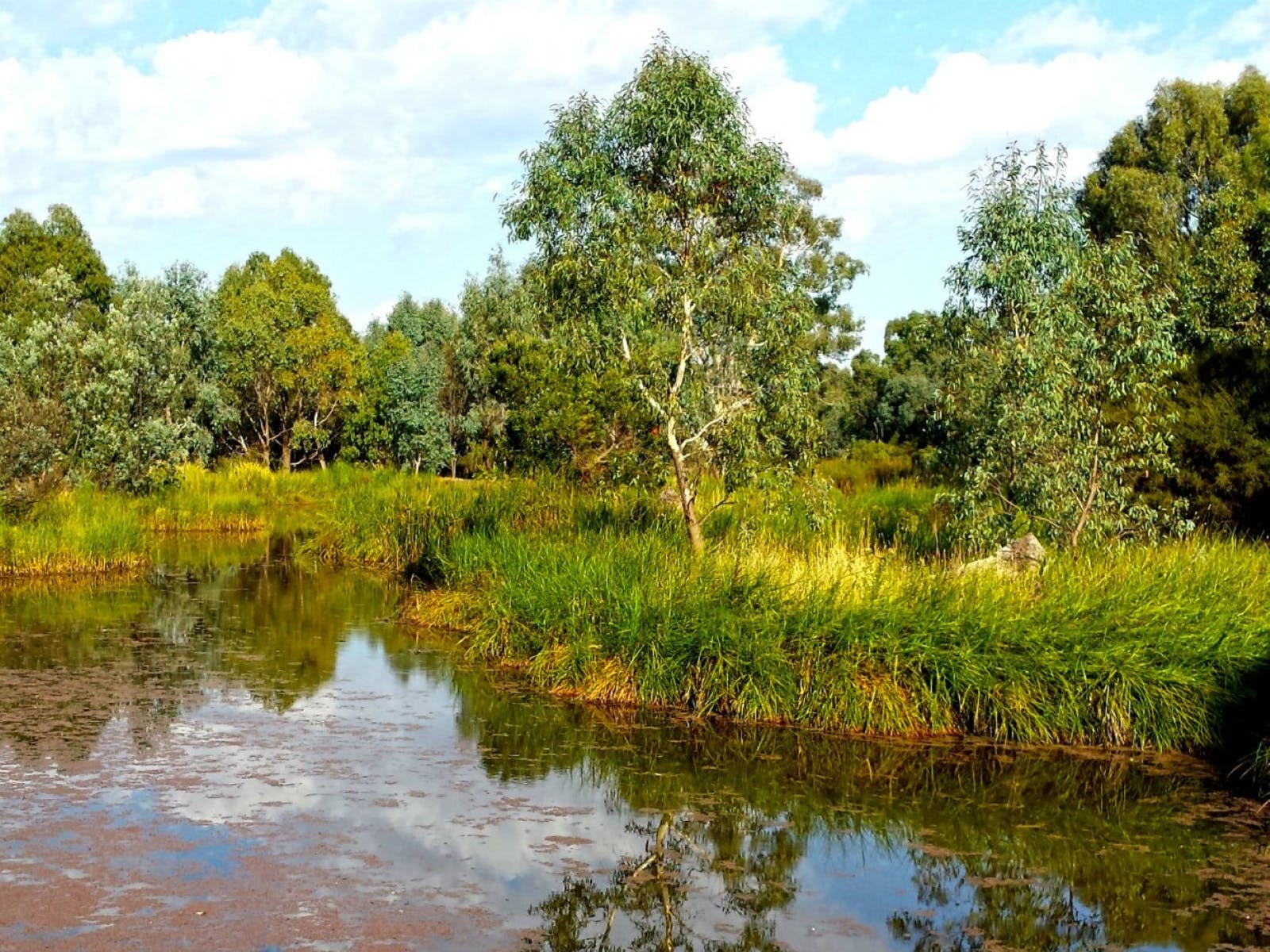
Mansfield has been developed around Ford Creek, which has a number of natural tributaries leading into it. Many of these watercourses may be dry outside of rain events but have naturally formed to funnel water from the wider catchment through Mansfield Ford Creek. The flooding mapping we see in the study shows us how water travels through these watercourses and where there may be flooding on roads and property.
Major development applications must provide stormwater plans to Council's engineering department so adequate stormwater planning at a precinct scale can be conducted. Large scale subdivisions are often required to include stormwater retention basins on-site to capture runoff and mitigate any downstream impacts.
Septic permits are issued by Council’s Environmental Health department. Officers take into account flood study data when considering applications. Where possible, effluent fields should be located outside of flood prone areas to protect water quality and mitigate any downstream impacts. Legacy systems in areas identified by the flood study will be assessed on a case-by-case basis when required.
The banks and bed of Ford Creek are managed by the Goulburn Broken Catchment Management Authority, while the water that travels through the catchment is under the purview of Goulburn Murray Water. Together these water authorities are responsible for the health of Ford Creek.
Mansfield Shire Council and the Goulburn Broken Catchment Management Authority engaged Stantec, an engineering firm with specialist experience in mapping flood scenarios to undertake the study. This was aided by community input, where residents had the opportunity to nominate historically flood-prone areas and provide general feedback. The modelling calculates a 1 in 100 year flood, which is considered best practice for future preparedness, and aligns with declared flood levels under the Water Act 1989.
The flood modelling for Mansfield shows a flood with a 1% AEP, also known as a ‘1 in 100-year flood’. This means there is a 1 percent chance each year that a flooding event will rise to or exceed this level. Importantly, this doesn’t mean a flood of this scale will only happen once every 100 years. Each year, the 1 percent chance resets, and it is possible to have multiple flood events at this level across a short window, or to not experience a flood of this scale across multiple generations.
The Goulburn Broken Catchment Management Authority are already using the data available to inform decision making. Council will seek to prepare a planning scheme amendment following the adoption of the final flood study.
Council encourages the community to provide feedback to the flood study, however any future changes to the flood mapping will require the approval of the Goulburn Broken Catchment Management Authority.
Council is offering weekly drop-in sessions in Council chambers where residents will have the opportunity to ask questions and view the draft flood study mapping. Details about upcoming engagement sessions are listed on this engage page.